A complete guide to the O Trek:
Hiking in Torres del Paine
About the National Park Torres del Paine
The »Turismo Lago Grey National Park« was founded in 1959. Just two years later the park was renamed as »Torres del Paine National Park«.
The Torres del Paine National Park (Parque Nacional Torres del Paine) is the most famous national park in Chile, surrounding the mountain range Cordillera del Paine in the south of Chile. The Aónikenk people, better known as the Tehuelche, were a group of indigenous peoples living in this area long before the Europeans discovered this region of the world. The word Paine means “Blue sky” in native Tehuelche language and is pronounced PIE-nay. The most important monument of the National Park Torres del Paine (“Blue mountains”) is the Los 3 Cuernos. The three granite mountains in the middle of the parc.

The park possesses a massive network of rivers, streams, and lakes all fed by the Southern Patagonian Ice Fields – the second most massive extrapolar contiguous Ice Field in the world. The largest is the Glacier Grey which can be visited by Kayak during the completion of the O Trek at Refugio Grey (add a half-day to your itinerary).
A great benefit, next to the stunning views over the glacier, is that you don’t have to carry water with you. There is plenty everywhere you go.
Occasionally, the park is associated with its unofficial title »Eighth Wonder of the World« and has been elected as the fifth most beautiful place in the world by National Geographic.
Both the W and the O Trek are entry level hiking treks. They offer an excellent opportunity to fall in love with the great outdoors.
How to get to Torres del Paine
Step one: International flight to South America
The easiest way to get to the Torres del Paine National Park is from Chiles capital Santiago de Chile. You can also reach it from Argentina, but this will take longer.
Step two: From Santiago de Chile to Punta Arenas
For more detailed information read our article “How to get to Patagonia.”
Step three: Bus from Punta Arenas to Puerta Natales
It is possible to take a bus directly from the Punta Arenas Pres Ibanez airport to Puerto Natales as well as to the Torres del Paine National Park. Check timetables ahead to avoid extra stops!
Alternatively, take a taxi from the airport to the city center, where the bus station is located; this will cost around 10.000 CLP. At the bus station, you can book a bus towards Puerto Natales.
Bus Sur
PUNTA ARENAS (City Center and Airport) – PUERTO NATALES
Price: 8.000 CLP
Duration: 3:15 hrs
Booking: https://www.bussur.com/venta-online/
Bus from Puerto Natales to Torres del Paine
There are some bus companies, which operate early morning shuttles to the National Park, but availability can be tight, make sure to book as early as possible.
PUERTO NATALES – TORRES DEL PAINE
PUERTO NATALES (City Center and Airport) – PUNTA ARENAS
Price: 8.000 CLP
Duration: 2:00 hrs
Booking: https://www.bussur.com/venta-online/
How long should I stay in Puerto Natales?
Visit Puerto Natales for at least one day. It’s a trekker’s heaven, where you can find everything you need for trekking in Patagonia (gear, food, tour bookings, extra cash, etc.) There are also endless day trip activities to consider.
There is a huge supermarket (UNI Marc) in the city center, where you can buy most of the food you will need for the trek. In case you didn’t make reservations for the refugios (camps) on the trek, you have the chance to visit and ask for a last minute reservation at one at the sales offices.
Last minute O Trek bookings from Puerto Natales
Make sure to book as early as possible. If the refugios are all booked out online, you can ask at one of the trekking tour organizers, but chances are slim.
FANTÁSTICO SUR
ventas@fantasticosur.com
Phone: +56 61 2614184
Esmeralda 661, Puerto Natales, Chile
CONAF OFFICE
consulta.oirs@conaf.cl
Phone: + (56) 61 2360014
Av. Bulnes 0309, Punta Arenas, Chile
VERTICE PATAGONIA
ventas@verticepatagonia.cl
Phone: +56 61 241 5716
Bulnes 100, Puerto Natales, Chile
There is a daily free information meeting about the W and O Trek at the Erratic Rock hostel. ![]()

If you are planning to drive with your car to Torres del Paine, make sure to have enough fuel; there is no gas station in the park itself. The nearest gas station is in Puerto Natales.
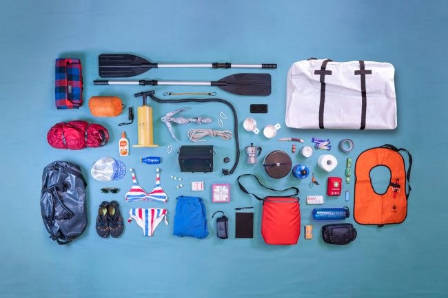
Key facts about the O Trek

Cost: Approximately 400€ (own tent and equipment)
Duration: 6–10 days
Distance: approximately 120 kilometers/ 74 miles
Highest point: John Gardner Pass 1220m
Difficulty: normal (most difficult part is the reservation for the refugios and campsites)
Start: Torres Norte
End: Torres Norte
The O Trek is open from 1. Oktober to 31. March.
The O circuit can only be hiked counterclockwise
Rules and Regulations:
- No open fires
- Camping Stoves are only
- permitted in the Refugios
- Leave nothing but footprints
- Stay on the trails
- Camping is permitted in the
- Refugios
- Do not feed the animals
- No Pets are allowed in the Park
- All visitors must sign the registration form.
Other activities in the Park
Ice Hiking
For more information:
http://www.indomitapatagonia.com/ES/index.html
Horse Riding
Kayaking:
Price: 81€ (66.000 CLP)
Duration: 2.5 hrs
Time: 9:00 / 14:00 / 17:00
Starting point: Refugio Grey
Available only from October to April
Climbing:
Before start climbing in the park, you need a permit and a few documents. Visit the Administration Office (close to the Lago el Toro) for more information. It is mandatory to obtain a insurance to start climbing in the park.
Refugio Las Torres Northe – Seron
In the Las Torres area you can find a campsite, a lodge, a hotel with good facilities and a small store.
Difficulty: medium
Length: 8,9 km
Duration: 4.0 hrs
Altitude: Hosteria Las Torres 190 m – Seron campsite 200 m

Seron – Dickson Refuge
During this part of the O Trek you will have an amazing view of the mountains and glaciers. At the end of the trail, you will have an excellent view of Paine Lake.
Difficulty: medium
Length: 18.5 km
Duration: 6.0 hrs.
Altitude: Seron 200 m– Dickson 220 m
Day 2 (Dickson Refuge)

Dickson Refuge – Los Perros Campsite
Day 3 goes through a Lenga forest with an awesome view of Glacier Grey and Perros Lake.
Difficulty: Medium
Length: 8.7 km
Duration: 4.5 hrs.
Altitude: Dickson 220 m– Los Perros 580 m
Day 3 (Los Perros Campsite)

Los Perros Campsite – Paso Campsite
The trail is winding through marshland and is covered by snow and ice. It is an arduous trek through an area of strong winds. Paso has a spectacular view of the Grey Glacier and part of the Southern Patagonian Ice Field.
Difficulty: medium
Length: 12.0 km
Duration: 6 hrs.
Altitude: Los Perros 580 m – Paso 400 m – Paso 1200 m
Day 4 (Paso Campsite)

Paso campsite – Grey Refuge – Paine Grande Mountain Lodge
The trail will follow Glacier Grey and it has a gorgeous view over the lake and icebergs. After a steep rise, the trek continues through a beautiful valley with a view of the Lake and Grey Glacier, crossing a Lenga, Coigüe and Ñirre forest, lagoons, and beautiful landscapes to finally reach Pehoe Lake.
Difficulty: Medium
Length: 21.0 km
Duration: 8hrs.
Altitude: Paso Campsite 400 m – Grey Refugio 90 m – Pehoe 40 m
Day 5 (Grey Refuge)

Pain Grande Mountain Lodge

Paine Grande Mountain Lodge – Italiano Campsite – Britanico Lookout – Italiano Campsite
An easier trek than the days before with a great view of Cuernos Del Paine. In Pehoe there is a CONAF park ranger station. Italiano campsite is only for camp, it does not have any services. It is recommended to stay at Los Cuernos Refuge.
Difficulty: easy
Length: 13.1 km
Duration: 5 hrs.
Altitude: Paine Grande Lodge 40 m – Italiano 200 m – Britanico lookout 600

Italiano campsite – Chileno
This trail has an excellent view of Nordensksöld Lake and Cuernos del Paine.
Difficulty: medium
Length: 22 km
Duration: 7 hrs.
Altitude: Italiano Campsite 200 m – Hosteria Las Torres 190 m
Day 7 (Chileno)

Chileno – las Torres – Refugio Las Torres Norte
The Last day of the O Trek will reach into the middle of the National Park, the Las Torres monument. This is one of the highlights of the entire trek.
Difficulty: medium
Length: 12 km
Duration: 7 hrs.
Altitude: Italiano Campsite 200 m – Hosteria Las Torres 190 m

How much does the O Trek cost!
For more detailed information read our article “W-Trek on a budget“
- Campsites: 8 nights 150 €
(Refugio Grey – Refugio Paine Grande – Refugio Cuernos – Refugio Chileno – Refugio Las Torres……………) - Gear Rental (optional)
tent, sleeping bag, stove, etc. cost 30€ per day (in Puerto Natales)
Rent a tent at the campsites CLP 20000 (25€)
Rent a sleeping bag at the campsites CLP 14000 (18€)
Rent a sleeping mat at the campsites CLP 5000 (6€) - Food: 160€ (20€ per day)
(UNIMARC Supermarket in Puerto Natales)
Eating in a restaurant approx. 15000 CLP (19€) per meal - Bus:
11€ (8.000 CLP) (Punte Arenas – Puerto Natales)
11€ (8.000 CLP) (Puerto Natales – Torres del Paine)
11€ (8.000 CLP) (Torres del Paine – Puerto Natales) - Entrance fee:
28€ (21.000 CLP) (1 October to 30 April)
15€ (11.000 CLP) (1 May to 30 September) - Fully guided O circuit tour cost around 2000€ per person this includes accommodation, a guide, entrance fee, ferry tickets, luggage transfer, food and transportation
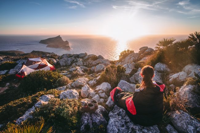
What is the best time to hike the O Trek
For more detailed information read our article “Weather in Patagonia“
The best time to trek in Patagonia is during summer. The season starts in December and ends during March. Due to the geographic length of the country (1500km), there is a high-temperature difference from north to south.
However, it always depends on what you are looking for. Spring can be fantastic in the lower altitudes, but you might need crampons or snowshoes in higher elevations.
The weather, in general, is volatile; be equipped for every situation.
Why should I hike the O Trek during the summer?
In Patagonia, it is normal that the wind speeds reach up to 100 km/h during a normal day. Keep this in mind while crossing a mountain ridge or while walking over a field of loose stones.
A wind protected campsite is a pleasure after a long and tiring day on the trek.
During summer time you will have nearly 22 hours of daylight. (Diagram)
What to eat on the O Trek!
10 Fast and Cheap Food Ideas for the O Trek
1. Nuts
2. Dried or fresh fruits
3. Cereal bars, chocolate & candy bars
4. Pasta
5. Oatmeal
6. Ramen & instant noodles
7. Tortillas with peanut butter or Nutella
8. Couscous
9. Instant Mash Potatoe with milk powder
10. Rice
Exiting Parque Torres del Paine
For your way back from the Parque Torres del Paine, you have three options: the Administration Office (close to the Lago el Toro) , Pudeto (Ferry) and Laguna Amarga Gate (where you bought your entrance ticket).
Timetable 1
1:00 pm Administration Office
1:30 pm Pudeto
2:30 pm Laguna Amarga.
4:30 pm Arrival to Puerto Natales
Timetable 2
6:30 pm Administration Office
7:00 pm Pudeto
7:45 pm Laguna Amarga.
10:00 pm Arrival to Puerto Natales
How to book campsites on the O Trek
The campsites on the O Trek are owned by two companies as well as the government. Each campground has to be reserved separately, and the operation of the individual websites can get frustrating due to page issues and loading speed which makes the planning of the trek quite challenging.
FANTÁSTICO SUR
ventas@fantasticosur.com
Phone: +56 61 2614184
Esmeralda 661, Puerto Natales, Chile
Booking:
http://int.fantasticosur.com/en/online
Campsites:
Sector Central, Sector Cuernos, Sector Chileno, Sector Francés, Sector Serón
Rate: 20 USD (13.000 CLP)per night (2018/19)
CONAF OFFICE
consulta.oirs@conaf.cl.
Phone: + (56) 61 2360014
Av. Bulnes 0309, Punta Arenas, Chile
Booking:
http://www.parquetorresdelpaine.cl/es/sistema-de-reserva-de-campamentos-1
Online booking wasn’t working. You have to go to the Office in Puerto Natales
Campsites:
Camping Italiano, Camping Paso,
Camping Las Torres (closed)
Rates: free
VERTICE PATAGONIA
ventas@verticepatagonia.cl
Phone: +56 61 241 5716
Bulnes 100, Puerto Natales, Chile
Booking:
https://reservas.verticepatagonia.cl/index.xhtml
Campsites:
Camp Dickson, Camp Grey,
Camp Los Perros, Paine Grande
Rates: 8USD (5.000 CLP) per night (2018/19)
If you are not on a budget, consider booking the complete itinerary with a trekking company, as it gets confusing with the different contacts, but be aware of the additional costs (approximately 1200€ extra).
I have never seen anything like those 3D Maps. Very cool! How do you make them?
Cheers, Derek.
Hey Derek!
Thank you so much! We use Photoshop and a plugin called “3D Map Generator – Atlas”. It is a lot of work, especially the texturing takes a lot of time. We love them too though! 🙂
All the best,
Bella