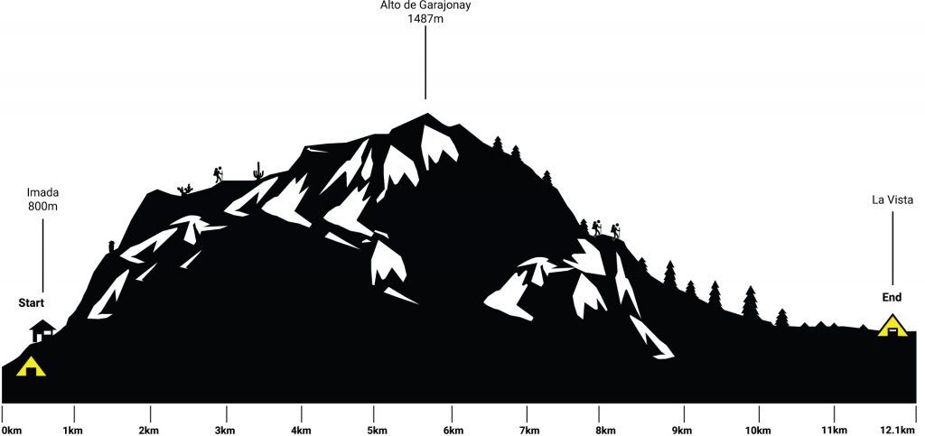
La Gomera Day 5
Imada – Le Cedro
Hiking: 12.5 km Ascent: 729 m Descent: 628 m Max Elevation: 1487 m
Well rested, it was time for the “assault on the summit”. Since we fell in love with the owner the day before, we made a quick stop at the Cedeteria Arcilla to order a cappuccino and to refill our food and water supplies. She gave us a cute little duck calendar – what a lovely lady – and I tried to explain where we were going, but due to my lack of Spanish the conversation quickly turned into a smiling competition.

Adiós, Imada! We followed the Calle Imada for a couple of meters, until we left the road towards Cumbres de Tajaque. We kept walking straight uphill for another 100 meters. From down at Imada, the mountain looked impossible to conquer.
A few rangers were preparing or improving new and existing trails up the mountain. These guys are incredible, with just a machete and a shovel they were climbing through impassable terrain. Thanks for making this adventure possible!

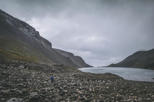
The windy path was exhausting. If somebody told me that we would have to walk up this mountain I wouldn’t believed him. The clouds ahead of us were falling from the top of the mountain, it looked like a waterfall made out of clouds.
As we reached the top a wonderful plateau awaited us. The vegetation was completely different, the barren landscape stepped aside and made room for a green plateau with flowers and trees. It was way cooler up there, so we had to change gear.
We crossed the road infront of us, and walked down to a water reservoir. The change of vegetation was really nice. The path lead us around the water reservoir towards Igualero. We made swift progress. In Igualero a huge pine tree marked the way up to Alto de Garajonay, the highest peak of La Gomera.
For the first time we could see the north side of La Gomera. The 2 km up to the highest peak were pretty easy and we had time to enjoy the view. The fires from 2012 destroyed huge parts of the forestation, burned tree trunks were the silent reminder of the force of nature (and people’s stupidity).

A paved road to the peak was the last stretch between us and the top of La Gomera. We were quickly surrounded by “hardcore hikers” who “conquered the peak” from the parking area a few hundred meter below the Alto de Garajonay.
The Alto de Garajonay (1489 m) was sacred to the pre-Hispanic inhabitants of La Gomera, the Guanches. They placed a sanctuary on its top, which now form two concentric stone circles. It is believed that the Guanches sacrificed animals and humans there.

As for the name, there is an old legend, saying that the children of two of the Guanche Kings fell madly in love with each other. Gara, the princess from La Gomera and Jonay, the prince from Tenerife. When it became obvious that their parents wouldn’t approve of their relationship, they fled to the highest point of La Gomera killing each other by sword. Ever since the mountain has carried their names.
We rested there for a couple of minutes and enjoyed the view with a bag of chips. The black lizards were quiet interested in our snack, but we were selfish and ate them all by ourselves. It was a great feeling to have walked up hear without any help.
Both extremely excited, we headed into the cloud forest. The hike to El Cedro through the laurel forest is one of the highlights of La Gomera.

Laurel forests usually arise on the slopes of tropical or subtropical mountains. The moisture from the ocean condenses and falls as rain or fog, resulting in soils with high moisture levels – ideal for laurel forests.
Shortly after we crossed the road to Alto de Garajonay we entered the laurel forest, there wasn’t any fog during our way down, so all looked a bit different than we expected. From here on, it went downhill all the way to the only official campsite (La Vista) on La Gomera. It took us 3,5 hours to reach our destination – way longer than we thought. We were counting every minute. This was the first trail were we met a lot of other hikers.
Close to Campamento Antiguo the trail forks, we took the right fork and climbed down to the stream and crossed over. After a long day of walking our legs were wobbly and the slippery stones were not the easiest way passing the stream.

The Cedro Stream is following the path for a few minutes. After another crossing over the river the path meets up with a forestry trail. We follow the signs to El Cedro until we reached the Ermita de Nuestra Senora de Lourdes. There was a beautiful chapel in the middle of the forest, but we were too focused to reach our destination, that we couldn’t enjoy the beauty of the place.
The descending trail went on for a couple of minutes until a clearing, we kept right and soon reached the village of El Cedro – finally!
La Vista was found quickly, but the reception was empty. A Polish couple explained us that the owner would be back the next day. We found a nice spot at the bottom of the camp site, our base camp for the next day.
There was just one tiny problem, we had nothing to celebrate our day off. The only solution was to run to the next village and get some cold ones. We emptied Bellas backpack and I took off.

My plan was to run to Los Acevinos and back, according to the travel guide it was 4.4 km (8.8km in total). I estimated a one and a half hour run. It was really nice to run, everything was passing by so quickly. Bella’s backpack was disturbing me, how can she hike with this backpack. In the right hand I was holding the travel guide to check my location. As I reached Acevinos I couldnt find an open shop and twilight approached rapidly. I had to turn around with an empty bag.
When I finally reached La Vista again, Bella was already best friends with Jakub and Magda, the Polish couple. After a few bottles of vine – which they bought in a close by winery – some schnapps and an alcoholic induced system crash we went to bed.